
Kendal Mountaineering Services is offering a Mountain Navigation Skills Training Course to members of the general public during the weekend of March 31st April 1st 2012.
This Navigation skills training course is ideal for anyone wishing to improve their map reading & navigation skills to allow them to venture into mountainous regions of the UK with confidence.
 The cost for the two day Mountain Navigation Skills training course is only £80 per person for the weekend. The price includes the provision of laminated maps for the areas to be covered in both 1:25 and 1:50,000 scales. You will need to provide your own compass for the course and we would recommend the Silva Type 4 Expedition compass for this Navigation Skills training Course.
Some previous experience of map reading & navigation techniques is useful but not essential- so if you lack experience do not worry!
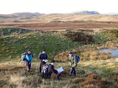 Kendal Mountaineering Services run their Mountain Navigation Skills Training Courses in The Lake District National Park usually in the Kentmere Area to the south.
The itinery requires us to meet on both days at 09:00 at Wilf's Cafe at Staveley Mill Yard in Staveley (LA8 9LR for those of you with Satnav). On day one we will travel to the nearby area of Green Quarter Fell to introduce basic map reading & navigation techniques providing a progression throughout the day for everyone - no matter what level of expertise you have.

Day two will see us travel further up the Kentmere Valley to walk part of the Kentmere Horseshoe. The emphasis will not be to cover miles of ground but build upon & consolidate navigation skills learned on day one - albeit on a slightly different and higher location.
The emphasis throughout the course will be to give you as many opportunities as possible to progress to a high standard of mountain navigational capability. We run all of our Navigation Skills Training courses to Mountain Leader Training (MLTE) Standard.
The following aspects of navigation skills will be covered during the course:-
Orientation of the map,
Grid references,
Measuring distance on the map & on the ground by pacing.
Tick off features,
Naismiths rule (timings c/w distance & contours),
Taking & walking on a bearing using a map, ie grid to mag,
Identifying from ground to map (Mag to grid),
Walking on a bearing/back bearings,
"Handrailing" using Linear features (eg streams/footpaths),
Aiming off,
Attack points,
Resections,
"Boxing" around an obstacle.
 The syllabus of this course is ideal -not just for someone wishing to improve their navigational ability for their own use but also for aspiring Summer Mountain Walking Leaders wishing to attend an ML Navigation Refresher course as part of their preparation for Mountainwalking Leader Assessment or for ML Navigation re-Assessment.
Candidates are welcome to book on to this Mountain Navigation Skills Training Course - or you can book your own personal Mountainwalking Leader Navigation Refresher day with Iain from Kendal Mountaineering Services at any time.
If you would like more information about this Lake District Based Mountain Navigation Skills training Course or would like to book please contact us here. You can view details of a few of our past courses on the Kendal Mountaineering Services Blog here and here.
We look forward to working with you.
No comments:
Post a Comment